Fájl:Deepwater Horizon oil spill - May 24, 2010.jpg

Eredeti fájl(2 118 × 1 628 képpont, fájlméret: 369 KB, MIME-típus: image/jpeg)

Ez a fájl a Wikimédia Commons megosztott tárhelyről származik, és más projektek is használhatják. A fájl ottani leírólapjának másolata alább látható.

Összefoglaló

Leírás
English: Description from NASA (source):

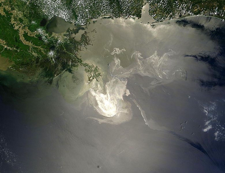
"NASA's Terra Satellites Sees Spill on May 24
Sunlight illuminated the lingering oil slick off the Mississippi Delta on May 24, 2010. The Moderate-Resolution Imaging Spectroradiometer (MODIS) on NASA’s Terra satellite captured this image the same day.
Oil smoothes the ocean surface, making the Sun’s reflection brighter near the centerline of the path of the satellite, and reducing the scattering of sunlight in other places. As a result, the oil slick is brighter than the surrounding water in some places (image center) and darker than the surrounding water in others (image lower right). The tip of the Mississippi Delta is surrounded by muddy water that appears light tan. Bright white ribbons of oil streak across this sediment-laden water.
Tendrils of oil extend to the north and east of the main body of the slick. A small, dark plume along the edge of the slick, not far from the original location of the Deepwater Horizon rig, indicates a possible controlled burn of oil on the ocean surface.
To the west of the bird’s-foot part of the delta, dark patches in the water may also be oil, but detecting a manmade oil slick in coastal areas can be even more complicated than detecting it in the open ocean.
When oil slicks are visible in satellite images, it is because they have changed how the water reflects light, either by making the Sun’s reflection brighter or by dampening the scattering of sunlight, which makes the oily area darker. In coastal areas, however, similar changes in reflectivity can occur from differences in salinity (fresh versus salt water) and from naturally produced oils from plants.

Michon Scott, NASA's Earth Observatory, NASA Goddard Space Flight Center"


Français : Traduction partielle de la description par la NASA(source):

La marée noire causée par l'incendie de la plateforme pétrolière Deepwater Horizon vue par le satellite Terra, de la NASA, le 24 mai 2010. Cette image a été acquise par le Moderate-Resolution Imaging Spectroradiometer (MODIS, pour Spectroradiomètre d'imagerie à résolution moyenne), embarqué sur le satellite Terra. Le pétrole lisse la surface de l'océan, ce qui la rend plus claire là où elle réfléchit le soleil (par exemple, au centre de la photo) et plus sombre ailleurs (par exemple en bas à droite). Le delta du Mississippi est visible en haut, entouré d'eaux saumâtres et boueuses qui apparaissent en brun, rayé de rubans argentés de pétrole.
Des dendrites de pétrole sont aussi visible au nord et à l'est. Un petit panache sombre près du centre de la marée noire, où se trouvait à l'origine la plateforme, correspond peut être à un feu contrôlé visant à la limiter.

A l'ouest de la "patte d'oiseau" que le Mississippi dessine dans le Golfe du Mexique, on peut voir des taches sombres, qui sont peut être du pétrole, ou peut être pas, car d'autres phénomènes peuvent avoir le même aspect dans ces eaux marécageuses et saumâtres.
Dátum
Forrás Original image, here cropped on left and at top
Szerző NASA/GSFC, MODIS Rapid Response
Más változatok
Kép of the year
Kép of the year
Featured kép

Wikimédia CommonsWikipédia

Ez a kép kiemelt a Wikimédia Commonson (Kiemelt képek) és egyike a legjobb képeknek.
 A 4:3-as és 5:4-es képarányú képek – így ez a kép is – alkalmasak háttérképként történő használatra (lásd még a galériát).

 Ez a kép kiemelt az angol Wikipédián (Featured pictures) és egyike a legjobb képeknek.

Ha van hasonló minőségű, megfelelő licencű képed, töltsd föl, jelezd a licencét, és jelöld kiemeltnek!

Licenc

Public domain Ezt a fájlt a NASA készítette, ezért az Egyesült Államokban közkincsnek számít. A NASA szerzői jogi irányelve alapján „a NASA anyagai nem állnak szerzői jogi védelem alatt, kivéve, ha az külön jelezve van". (Lásd még: Sablon:PD-USGov, a NASA szerzői jogi- és a JPL képhasználati irányelve.)
Figyelmeztetések:

Képaláírások

Adj meg egy egysoros magyarázatot arról, hogy mit mutat be ez a fájl
24 May 2010 satellite image of Deepwater Horizon oil spill in Gulf of Mexico

A fájl által ábrázolt elemek

mű tárgya

24. május 2010

Fájltörténet

Kattints egy időpontra, hogy a fájl akkori állapotát láthasd.

Dátum/időBélyegképFelbontásFeltöltőMegjegyzés
aktuális2010. május 26., 07:26Bélyegkép a 2010. május 26., 07:26-kori változatról2 118 × 1 628 (369 KB)APK== Summary == {{Information |Description={{en|"Sunlight illuminated the lingering oil slick off the Mississippi Delta on May 24, 2010. The Moderate Resolution Imaging Spectroradiometer (MODIS) on NASA’s Terra satellit

Metaadatok